Goal 4 Report – The Future of the USB
The Future of the Urban Service Boundary: Goal 4 Work Group
 LFUCG is currently having the most important conversation related to the Urban Service Boundary since its inception in 1958. The efforts of a stakeholder group called the Goal 4 Workgroup will help to inform decisions made by the Planning Commission and the Urban County Council about the Urban Service Boundary and future growth decisions in the 2023 Comprehensive Plan.
The recently released Goal 4 Report has raised alarming questions and fundamentally incorrect assumptions about expansion of the Urban Service Boundary to allow future growth. It proposes a map that destroys the concept of the USB and suggests a legally questionable process for determining how future expansion decisions will be made. Further, the Report was developed on a fast-tracked timeline without the broad community input essential to public policy decisions. Before any growth proposal is considered, the community deserves more information, better data, public input, and a hard look at the impacts, necessity and appropriateness of development in the RSA.
Lexington-Fayette County has again begun difficult but necessary conversations about growth. If done carefully, discussions can be grounded more in data than politics and result in policies that meet our community’s needs and protect the prime farmland that is the factory floor of the multi-billion dollar agriculture industry and also provides its unique identity. If not, discussions put at risk the irreplaceable land that sustains thousands of jobs and provides a special quality of life that sets us apart from cities across the country without creating more affordable housing, sustainable infrastructure investments, or supporting jobs leveraging Fayette County’s key attributes.
While the community should have research-based discussions about where and how to grow, it is irresponsible to make public a map proposing over 27,000 acres of land in the rural area for future development. In the 26 years since the last expansion of the USB, a little over 2,500 acres has been developed; just half of what was brought inside the USB at that time. Using this rate of development, the Report identifies enough land to accommodate growth for over 200 years before determining how much might realistically be needed, when, where, and for what reasons.
The proposals in the Report are not only irresponsible, they are inefficient. The Report indicates land could be developed in multiple directions outside the USB at the same time, incentivizing scattered development throughout the rural area, unsustainable infrastructure investments, and negative impacts to agricultural businesses that local, state, and federal dollars have invested tens of millions to support through the Purchase of Development Rights Program. The last time Lexington-Fayette County failed to consider the relationship between development and infrastructure capacity, overflowing sewers caused serious harm and the EPA sued, resulting in a consent decree settlement which will cost taxpayers close to $600 million to correct (until completion in 2026). The process set up by the 1996 expansion to ensure developers pay their share for infrastructure to serve new development outside the USB, like roads and sewers, has failed and the Report doesn’t propose a new one. This leaves major questions for LFUCG and Lexington-Fayette County taxpayers that must be answered.
The workgroup process resulting in the Report may have begun with good intent, but ended abruptly, failing to include updated data, key stakeholders, public input, or analysis of major issues that now must be addressed. While reliable data is important for public policy decisions, even more important is the involvement of the community in making them. A decades-long plan for growth is not as simple as drawing lines on a map, nor is it appropriate for a small group of people in a closed room to decide where and how growth should occur. The Report does a disservice to our community if the fundamental issues aren’t acknowledged up front. There must be a review of the process, a commitment to updated research, and an opportunity for input from those who will be most impacted by future growth decisions.
The best next steps to informed discussions are: 1) an update to the Sanitary Sewer Capability Study that was used as a basis for the Report, 2) an update to the 2017 Rural Land Management Plan, the most comprehensive resource and guide to the rural area, and 3) an updated Cost of Community Services Study to explain what growth outside the USB will cost the community in the long term. In the meantime, Comprehensive Planning efforts should focus on infill and redevelopment of vacant and underutilized land inside the USB, using existing infrastructure to meet the needs of a growing population, and updating zoning policies to incentivize new development.
Lexington-Fayette County has been a national model for planning and zoning since 1958. Let’s continue to lay the groundwork necessary for truly responsible growth. To make your voice heard, attend the Planning Commission meeting on Thursday, December 8th at 1:30pm at the LFUCG Government Center, 200 E. Main Street, 2nd floor.
Background
On November 7th, the Goal 4 Workgroup released its report, made only over the course of 12 meetings, which includes a map of Fayette County indicating land for permanent preservation, land that is sewerable and has the potential for future development, and a process that can be used by the Planning Commission and the Urban County Council to make long term decisions about growth, the need for, and implementation of (once a need is identified) expansion of the Urban Service Boundary. Public comment on these processes was not permitted throughout the meeting of the group or before the report was finalized, and not until the Council of the Whole meeting which took place on Thursday, November 10th.
The Goal 4 Workgroup, appointed by Vice Mayor Steve Kay (and led by Kay and Councilmember James Brown) is the second phase of the Sustainable Growth Task Force, which was appointed last year by Mayor Linda Gorton. The Sustainable Growth Task Force identified data points and a data-driven framework for how to evaluate existing conditions in Fayette County related to housing, industrial, commercial and retail development, and whether we can continue to meet our growth needs through infill and redevelopment and at what point we might need additional land outside the USB to do so.
Both of these working groups were formed to complete the task set out in the 2018 Comprehensive Plan, Imagine Lexington, in Theme E, Goal 4, which reads:
- Goal 4: Protect Lexington’s invaluable rural resources and inform long-range planning for infrastructure, community facilities, and economic development through the creation of a new process for determining long-term land use decisions involving the Urban Service Boundary and Rural Activity Centers.
- Establish the process via a study, involving diverse stakeholders and constituents, that meets the projected need of the agricultural and development communities, by preserving key agricultural resources from development pressures and identifying land for future urban development.
- Ensure the study designates rural land for long-term preservation, identifies land for potential future urban development, and specifies triggers, thresholds, and timing for the addition of the identified urban land into the Urban Service Boundary, keeping infill and land use efficiency as the continued primary objectives.
What’s in the Report?
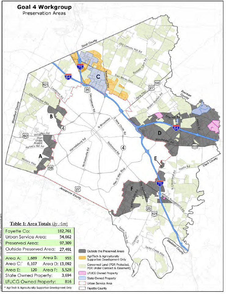
The Preservation Map set forth in the report was created on a foundation of the sewerability areas developed as part of the 1999 Rural Land Management Plan. The map shows there are 182,761 acres in Fayette County, 54,662 acres of those within the existing USB. This Report designates 97,309 acres in the “permanently preserved area”, and designates 27,491 acres “outside the preserved area” or as areas for potential future development based on their ability to be sewered. There is no designation on the map reflecting the cost or feasibility of sewering land for potential development – which was key in the 1999 Plan.
The remainder of the report is an outline of ways in which the Planning Commission and Urban County Council could evaluate when there is a need to modify the Urban Service Area (which process incorporates the work of the Sustainable Growth Task Force). After a review of the data involved, if a decision is made to initiate a conversation to consider expanding the Urban Service Boundary, the Report outlines a proposal process, similar to a call for private development proposals, within the future development area that would meet the need identified in the prior step.
Pursuant to the Report outline, developers would have to show the proposed development is: fiscally sustainable, equitable, environmentally focused, multi-modal, agriculturally supportive, and economically forward; a public engagement process with surrounding stakeholders, infrastructure/community facility planning, and more, in order to be approved in the Urban Service Area. The proposal would go through the public hearing process similar to a zone change under the current ordinance.
What’s the Status of the Report and What’s Next?
|
Pause on ZOTAs in the Rural Service Area Until the RLMP is Updated
BGT Magazine – History of RLMP and PDR – Nov 22