The Urban Service Boundary and the Future of Lexington-Fayette County
If you asked ten people what makes Lexington-Fayette County such a special place, you might receive ten different answers. It’s bourbon country, horse country, home to great industries and educational institutions.
Like any good bourbon, Lexington’s distinct appeal comes from its blend and balance, which is largely supported by a unique feature: the Urban Service Boundary (USB).
Also known as the “Green Belt,” Lexington’s Urban Service Boundary protects our productive farmland and unique soils from development, prevents urban sprawl, and encourages the county to grow thoughtfully and intentionally.

Lexington-Fayette County was the first place in the nation to implement an Urban Service Boundary back in 1958. They put the boundary in place because they knew that it matters how we grow. It’s crucial to have a plan that takes into account all of Lexington-Fayette County’s residents. Financially, the boundary was created to limit the costs the city would incur if it failed to grow with intention.
Without a plan, sprawl and congestion are inevitable. Without a plan, Lexington loses its character and becomes just another complicated place to live. You don’t have to look far to find places that have grown haphazardly.
The Urban Service Boundary is sometimes called the “Growth Boundary.” That label is a little disingenuous. The USB has never been anti-growth, anti-development, or anti-progress.
It comes down to common sense. To act as good stewards of this special place, we need to make the most of what we have before taking more. Because once our land is gone, there’s no getting it back.
Quick Facts About the Urban Service Boundary
The effects of the Urban Service Boundary are far-reaching and sometimes unexpected. By understanding its many factors, we can make more informed decisions about the future.
The Urban Service Boundary was never meant to be static.
It was last expanded in 1996 to include 4,200 additional acres for development. However, 25 years later, only 50% of those additional 4,200 acres have been developed, and none of it was developed to provide affordable housing—as promised at the time—or address other housing issues still at play in Lexington today.
If we haven’t used all the land from the previous expansion, why expand it again?
Rural land protected by the USB contributes massively to our economy.
Today, 70% of Lexington-Fayette County is designated as “rural” and falls outside the Urban Service Boundary. It may seem like that land is just sitting there doing nothing, but that couldn’t be further from the truth.
Lexington-Fayette County’s rural area is home to thousands of residents and businesses, and dozens of small communities — including historically African-American hamlets like Bracktown and Cadentown — whose way of life would be impacted by expanding the Urban Service Boundary. In addition, the “rural” area also includes major employment centers like the Bluegrass Airport, Keeneland, Bluegrass Stockyards, Kentucky Horse Park, and Bluegrass Station, all critical to Lexington-Fayette County’s economy.
Not to mention, the farms in Lexington-Fayette County employ thousands of people— 16,000 jobs in Lexington-Fayette County are directly or indirectly dedicated to agriculture.
Our agriculture industry is world-renowned, and the beauty of our farms brings in major tourism dollars from outside the county. Tourism brings $2 billion to Lexington each year, especially farm tours, which are still the most requested experience in our county.
The bottom line: the businesses and people living in Lexington-Fayette County’s rural areas contribute $2.6 billion to our local economy each year, and $12.9 million annually to the local tax base. In addition, the agriculture industry generates an additional $1.3 billion in income, profits, and dividends.
Expanding and developing the USB would be expensive.
To expand the boundary and develop within it would require city services to expand into this new area. Roads, sidewalks, plumbing, street lights — all of that infrastructure costs taxpayer dollars and takes time to plan and construct.
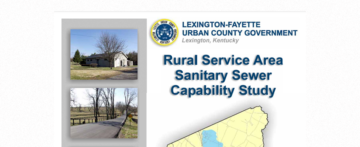
In 2006, Lexington conducted a study to estimate the cost of expanding the sewer system into rural farmland. They found it would cost almost $17,000 per acre. It’s likely that number would be even higher today.
The costs don’t stop once the infrastructure has been built. Garbage trucks, police, and school buses have to service this new area. The city has to power more street lights every night and maintain these new streets indefinitely.
The sewer system in particular presents astronomical costs. In 2006, the Environmental Protection Agency sued Lexington because the city had not maintained its sanitary and storm sewer systems, resulting in severe and widespread overflows.
Currently, the city is under an EPA mandate until 2026 to update its existing sewer system. The costs of these updates–which are paid for in increased sewer fees to community members–are projected to top $500 million—not including costs for the additional infrastructure that expansion would require.
The EPA consent decree significantly impacts our City budget. Per CivicLex, environmental and energy costs account for 22% of the entire city budget, most of which is attributable to the consent decree.
Expanding the USB, and thus the sewer system, would increase these costs exponentially and significantly impact Lexington’s budget.
Developing within the USB would help keep these costs under control by allowing us to take advantage of the infrastructure that already exists, using the land we have to meet our needs.
Lexington’s Comprehensive Plan already outlines a path for growth.
Every five years, Lexington’s Planning Commission, Planning Staff, and Urban County Council approve and make alterations to Lexington’s Comprehensive Plan. This 20-year plan details the policies and actions the county will take to grow responsibly.
This doesn’t mean that every five years, the Planning Commission comes up with an entirely new plan for Lexington’s growth. Rather, the Planning Commission examines its progress and builds more detail into the plan to keep it on track toward its goals.

The current plan, known as Imagine Lexington, was created over the course of two years by gathering input from over 10,000 Lexington voices from all walks of life. Approved in 2019, the Imagine Lexington Comprehensive Plan is incredibly thorough in how to grow our area responsibly, with no need to expand the Urban Service Boundary.
Addressing the Challenges of Growth
Lexington faces the same challenges as most cities do when experiencing significant growth — housing affordability and gentrification, transportation and traffic, climate impacts, and more.
There is no evidence that expanding the Urban Service Boundary will offer any solutions to these challenges that can’t also be achieved with the existing urban designated land. These issues won’t be solved with a single policy decision. It will take a range of policies to adequately meet these challenges and protect what we all love about living in Lexington.
Housing
Thanks to the pandemic, historically low housing inventory, and record-low mortgage rates, the entire country is seeing an explosion in housing prices. Nationally, home prices rose over 13.2% from March 2020 to March 2021, the highest growth since pre-2008.
How do we know housing affordability is a problem in Lexington?
- The average sale price of a home currently stands at $250,000, up 9.6% from last year.
- In 2021, Lexington saw the fourth-highest rent increase in America’s 100 largest cities. The average rent for a two-bedroom apartment is $1,107, up 13.3% from last year and up 14.4% since before the pandemic.
- In the last 15 years, the median home price in Lexington has risen 37% higher than household wages have risen. Many Lexingtonians are on a waitlist to get into rental units across the city, but many risk running out of money in the meantime.
How does the USB affect housing affordability?
It may seem like the USB stands in the way of building more affordable housing, but that’s not the case.
In fact, a 2017 study by the Lexington Bluegrass Association of Realtors (LBAR) shows that expanding the USB in 1996 did virtually nothing to slow the increase in housing prices and states that any future expansion of the USB would only have a short-term effect on the cost of housing.

There’s plenty of land within the boundary (17,000+ acres) that can be developed or re-developed for housing. But the truth is that more land doesn’t automatically equal more affordable housing. We know that from the 1996 boundary expansion.
Lexington doesn’t just need more housing, it needs more types of housing to make housing more affordable. Duplexes, triplexes, apartment complexes, and single-family homes on smaller lots will provide the “missing middle” housing that our area needs. This housing is accessible to renters, first-time homebuyers, workforce housing, and seniors living on a fixed income.
The location of this housing matters. Putting lower- to middle-income families farther away from jobs, schools, and grocery stores simply shifts housing costs to transportation costs, as residents would face longer commutes to get into the city.
The combined costs of housing and transportation paint a fuller picture of housing affordability. The housing and transportation affordability index shows that transportation accounts for 24% of the average Lexingtonian’s income. Expanding the boundary for affordable housing would only increase that burden.
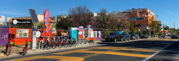
Building affordable housing close to urban centers would lower transportation costs for all residents because it would allow them to take advantage of Lexington’s public transportation and more than 30 miles of bike and pedestrian trails throughout the city. When they do drive, it will be for shorter distances, which will help keep traffic volume under control.
Gentrification & Displacement
Gentrification & displacement are real issues for growing cities both big and small all over the country, and Lexington is no different. Right now, countless longtime residents of the East End and Northside, and other historically underserved neighborhoods are being displaced by gentrification.
Gentrification is when wealthy people move into a poor area, and by improving housing and attracting new businesses, raise the cost of living in that neighborhood so that the original residents of that neighborhood can no longer afford to live there.
How does gentrification happen?
A better question is, how does an area become low-income in the first place? Areas most vulnerable to gentrification are neighborhoods that have been historically disinvested.
Revitalizing an area doesn’t have to erase the identity of a neighborhood or displace its residents. These negative effects happen when higher-income residents and developers act according to their own interests alone, neglecting to consider what kinds of investments the community actually wants and needs.
When there are no policies in place to protect existing community members and keep people in their homes, displacement is guaranteed to happen.
What part does the USB play in gentrification?
Expanding the boundary doesn’t help gentrification at all. It does nothing to keep residents of disinvested neighborhoods in their communities. In fact, it encourages displacement to newly developed areas far from their jobs and the neighborhoods they love.
It’s possible to invest in a neighborhood in a way that allows its residents to enjoy the fruits of that revitalization. We call these community-driven investments. Community-driven investments take the existing residents’ wants and needs into consideration and should accompany local policies in place to mitigate displacement.
Expanding the USB and creating new neighborhoods would stretch the city’s budget even thinner, further contributing to the disinvestment of neighborhoods that need it most. Intentional policies preventing displacement are the solutions necessary to support marginalized neighborhoods.
Keeping the USB as it is would support more community-driven investments because it forces our community to focus on and invest in what we have instead of building new.
Traffic & Congestion
The strategy for controlling traffic congestion is simple: minimize the number of vehicles on the road, and minimize the amount of time they spend on the road.
Expanding the Urban Services Boundary would worsen both factors. By building more housing farther from the community center, the residents would face longer commutes. Furthermore, their personal vehicles would be their only option for transportation.
How does the USB minimize traffic and congestion?
Maintaining the current USB encourages development in areas closer to jobs, grocery stores, schools, and other places where life happens. That means less time on the road.
Solving traffic congestion also demands policies that offer more diverse forms of transit. Making Lexington more walkable and bikeable keeps cars off the road, as does the addition of public transportation initiatives like the Imagine Nicholasville Road Plan.
King County, Washington has employed an infill redevelopment strategy to great success. They’ve found that residents of walkable neighborhoods drive 26% fewer miles per day, and people living in places with greater density and diversity of travel drive about a third less than sprawl area residents. It’s a great example of how policies can lead to real community change.
Environmental Impacts
2021 was a tough year for Kentucky. In February, an ice storm tore down trees and cut power for 150,000 residents of eastern Kentucky. In July, flash floods stranded people in their homes. In December, tornados slashed through the state leaving thousands of families homeless and without electricity.
It’s not just bad luck. Kentucky is the ninth most threatened state in the country by long-term climate change impacts — ahead of even California.
- In the past 126 years, 4 of Kentucky’s top-10 years for rainfall have occurred in the past decade. Between 2017 and 2019, Kentucky experienced two floods, three severe storms, and one freeze that cost the state over $1 billion.
- Climate volatility is also increasing—more floods and more droughts. In 2019, Lexington saw no rain between August 28 and October 5, yet still ended the year 11 inches wetter than average.
Climate impact affects everything. Though it will produce longer growing seasons, the increased frequency and severity of droughts and hot days will diminish yields of corn, soybeans, and livestock. It will change the composition of Kentucky’s forests, wildlife, and aquatic ecosystems. It will pose health risks and form ground-level ozone, a component of smog.
Development is a threat to our endangered soils.
Creating more sprawl on our farmland will impact the livelihood of our region. In 2006, the World Monument Fund named the Bluegrass Region one of the most endangered landscapes in the world under threat from development.
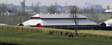
The soils of the Inner Bluegrass Region are a crucial component of agriculture and tourism. The limestone present in our soils makes this an ideal place to grow corn for bourbon and to filter the water that strengthens the bones of our racehorses. This soil isn’t a feature of the entire state, only the inner Bluegrass Region in which Lexington-Fayette County resides.
Once we run out of those soils, or compromise them, there’s no getting them back.
Climate impacts endanger our marginalized neighbors.
Lexington’s carbon impact has been especially concerning. In 2005 and 2008, the Brookings Institution found that Lexington had the highest emissions per capita of any region in the country.
Marginalized communities are disproportionately impacted by climate change.
- Young people will suffer from asthma more frequently, thanks to a longer allergy season. Lead exposure is also highest during hotter months. Flooding and water contamination can increase rates of neurological disorders.
- The elderly, especially those with pre-existing conditions like diabetes and respiratory diseases, are more vulnerable to heatstroke, heart attacks, and other issues caused by extreme temperatures. Those who are receiving long-term care are especially at risk during power outages and other infrastructure disruptions.
Low-income residents and people of color tend to live in areas with the greatest exposure to climate and extreme weather events.
- According to an EPA study, black and African American citizens are 35% more likely to live in areas with the highest projected increases in childhood asthma diagnoses. 40% are more likely to live in areas with the highest projected increases in extreme temperature-related deaths. These risks will only increase as our climate footprint becomes larger.
- Latinos are more likely to work in weather-exposed industries like construction and agriculture and are consequently more vulnerable to extreme temperatures. At the same time, Latino workers are 43% more likely to live in areas with the highest projected reductions in labor hours due to extreme temperatures, thus reducing their income.
Recovering from natural disasters is expensive, both for the city and for individuals. Marginalized populations are more easily destabilized by the effects of climate change and have less ability to re-stabilize in the aftermath of an event.
What does a climate-resilient city look like?
Buffalo, New York is taking proactive steps to build its climate resilience in the face of population growth. Buffalo and the surrounding Erie County have pursued a smart growth strategy and are seeing compelling results.
- County departments are combining climate change initiatives with affordable housing initiatives, working with low-income households to provide community access to bulk energy and green energy purchasing. They are also making energy efficiency improvements throughout the community to lower energy costs for low-income households.
- The City of Buffalo is meeting the demands of economic growth by creating mixed-use, higher-density neighborhoods along its major transportation corridors. This keeps workers close to jobs, minimizes drive time on Buffalo’s roadways, and lower’s the city’s carbon footprint.
- Like Lexington, Buffalo faces floods and stormwater challenges that threaten to compromise the area’s water quality. The Buffalo Sewer Authority and the City of Buffalo are using green infrastructure to reduce stress on the area’s sewer system, thereby lowering the cost of damage and preserving the water quality.
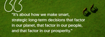
The University at Buffalo has partnered with numerous municipalities and businesses to create the One Region Forward sustainable development plan. Ryan McPherson, chief sustainability officer at the university, said that sustainability means thinking about decisions over the course of several generations.
“It’s not about tree-hugging and Birkenstocks,” McPherson said. “It’s about how we make smart, strategic long-term decisions that factor in our planet, that factor in our people, and that factor in our prosperity.”
The solutions for Lexington may not look exactly like Buffalo’s plan. However, every successful climate resilience plan has two things in common.
- These local governments take a proactive, holistic approach, rather than a reactive, ad-hoc approach to mitigating climate impacts.
- They involve input from a wide spectrum of stakeholders to understand their current position, set ambitious goals, and innovate to meet those goals.
How does the USB minimize the environmental impacts of growth?
Much like housing, making Lexington more climate-resilient will require a host of initiatives and policies. Expanding the Urban Service Boundary, however, would be a step in the wrong direction.
Over the past half-century, we’ve made room for more people by building housing farther and farther away from job centers (i.e. Hamburg). Advances in eco-friendly engines and less harmful fuel have been negated by more people on the road, driving longer and longer distances.
Expanding the boundary will do just that.
Developing within the boundary will allow Lexington to grow its population without growing its carbon footprint. It will also reduce infrastructure costs, storm-water runoff that pollutes our waterways, and pollution in the air we breathe.
Keeping the Urban Service Boundary
There may come a day when expanding the Urban Service Boundary is the right choice, but now is not the time. We have the land and the creativity to get more out of what we already have and to act as faithful stewards of our land and resources.
Fayette Alliance has always stood for growth—smart growth. It’s not if we grow, it’s how. As we’ve advocated for a balance between our vibrant community and the productive farmland that surrounds it, we’ve also championed smart policies that protect and improve our urban centers.
The choice between expanding or keeping the USB isn’t a choice between keeping Lexington’s identity or embracing progress, between growth and equity, or between sustainability and profitability. In all these cases, keeping the current boundary and committing to infill redevelopment and zoning reforms allows Lexington to have the best of all worlds.
The only choice is between reckless short-term profit and long-term sustainable investments. Smarter, community-driven investments within the boundary offer a win-win for everyone — for our farms and rural residents and business owners, for our suburban and urban residents, and for the business and development community. That is smart, sustainable, and equitable growth.