The Urban Growth Management Plan Advisory Committee
August 8, 2023
The Urban Growth Management Plan Advisory Committee met for the first time today to begin planning for an expansion of Lexington’s historic Urban Services Boundary. This first meeting served as an introduction to the weeks ahead. The committee introduced themselves and reviewed their assignment and timeline.
The 14-person committee is compromised of LFUCG staff, community leaders, and Councilmembers. Over the next six weeks, this committee will meet once a week to identify land to be incorporated into the boundary, working towards a deadline of September 26, 2023.
Once the committee has made its decision, it will make its recommendation to the Planning Commission on which parcel(s) of land they believe would be best suited for new development.
- Important: This group has been tasked by Council to identify 2,700-5,000 acres for expansion and development.
- History: This is the first time in Lexington’s history that the LFUCG Urban County Council has dictated an expansion. This decision has historically been made by the Planning Commission.
After the committee has presented its recommendation, the Planning Commission will vote on either adopting or rejecting the committee’s decision.
If the Planning Commission adopts the committee’s decision, they will move forward with creating an Expansion Area Master Plan, which will serve as the definitive guide to new development in the expansion area.
- Need to know: An expansion of the Urban Services Area will not become official until October/November of 2024.
These meetings are open to the public and public comment will be accepted throughout the entirety of the process, with committee members being updated with comments on a weekly basis. You can email your comments to imagine@lexingtonky.gov.
All meeting information, schedules, meeting packets, and minutes are available on the Imagine Lexington website, linked here.
Schedule
August 15 – PVA Report; Sewerability Study
August 22 – Building the Draft Map
August 29 – Building the Draft Map
September 5 – Finish the Draft Map
September 12 – Public Input Meeting about the Draft Map
September 19 – Address Public Input About the Draft Map
September 26 – Finalize Recommendations of the Draft Map
Resources
Questions – imagine@lexingtonky.gov
Meeting Details – imaginelexington.com/ugm
Watch – youtube.com/c/LEXTV
August 15, 2023 – PVA and Sewer Study
The Growth Management Plan Advisory Committee’s second meeting focused on two essential aspects of Lexington’s rural area:
- The Purchase of Development Rights (PDR) program
- A Sewer Capability Study
The committee will take into consideration land that is protected by the PDR program and land that is most fiscally and environmentally responsible to sewer when deciding on which parcel(s) of land it should incorporate into the Urban Services Area.
Below, we have outlined the two presentations to provide you with a better understanding of the Purchase of Development Rights program and the feasibility of sewering land outside the Urban Services Boundary.
Purchase of Development Rights (PDR)
The committee first heard a presentation from Beth Overman, Purchase of Development Rights Director.
Purchase of Development Rights is Kentucky’s first Agricultural Conservation Easement program facilitated by a local government, and the presentation informed committee members on what types of development could, and could not, take place on and around PDR-protected land. The farms under PDR easement are a mix of cattle, equine, crops, and general agricultural uses.
-
- Definition: This program allows the LFUCG to purchase, with a combination of local, federal, and state dollars, farm owners’ development rights — protecting the farmland from commercial and residential development and preserving it as farmland forever.
- Goal: The program works to preserve large contiguous tracts of prime farmland in Fayette County — protecting the highest quality and nationally recognized soils in Fayette County from development.
By the numbers:
- Fayette County is approximately 182,000 acres.
- 54,000 acres exist inside the Urban Services Boundary. (30%)
- 128,000 acres exist outside the Urban Services Boundary. (70%)
- The PDR program protects 31,066 acres of this land, or 285 farms.
- The PDR program aims to protect 50,000 acres of farmland in total.
- Approximately 112,000 acres or 88% of the Rural Service Area (outside the USB) are federally designated prime farmland and soils of statewide significance.
Development:
Once a farm is protected by a PDR easement, it cannot be developed and is protected for agricultural uses in perpetuity.
- Need to know: Residential suburbs, shopping centers, restaurants, and industrial builds can never be built upon PDR-purchased property. Federal requirements prevent local easements for sewer or utility easements, meaning PDR property cannot accommodate new infrastructure to serve other development.
- More: The landowner must even go as far as seeking approval from the Rural Land Management Board before expanding existing housing or adding pavement to the property.
Rural Sewer Capability Study
Additionally, Charlie Martin, Director of the Division of Water Quality, presented the 2023 Rural Sewer Capability Study to the committee.
The study featured 14 different areas of land outside the Urban Services Boundary and showcased the complexity of Lexington’s sewer system. The fact that Lexington doesn’t have a large river running through its downtown, like most major US cities, complicates the issue even further.
- Analogy: A city’s sewer system operates like a bathtub; the outlet drain is the treatment plant.
- Fact: Fayette County has eight main bathtubs, as well as multiple smaller ones, but only two drains (treatment plants). This means all of the water that Lexington’s current and future residents use must go through either the Town Branch Treatment Plant or the West Hickman Treatment Plant.
The committee will take into consideration the need to add or remove pump stations to accommodate new growth and expansion while ensuring that neither of Lexington’s two treatment plants gets pushed to their maximum capacity.
Developable Acres
The committee was also presented with a map and spreadsheet that documented both the gross acres and total developable acres for each of the 14 different study areas. Please see the chart and map below for reference.
| RSA# | RSA Name` | Gross Acres | Developable Acres |
| 1 | Lower South Elkhorn | 1,219 | 794 |
| 2 | Mint Lane | 572 | 537 |
| 3 | Man O War | 375 | 336 |
| 4 | Old Frankfort Pike | 1,682 | 764 |
| 5 | Iron Works Pike | 6,909 | 2,093 |
| 6 | Royster Road | 2,354 | 1,921 |
| 7 | Avon / I-64 | 4,046 | 2,405 |
| 8 | Avon / I-64 (Extension) | 10,165 | 6,026 |
| 9 | Chilesburg / Walnut Hill | 124 | 68 |
| 10 | Athens – Boonesboro | 298 | 273 |
| 11 | Lower East Hickman | 4,622 | 2,821 |
| 12 | Boonesboro Manor | 504 | 428 |
| 13 | Canebrake | 188 | 149 |
| 14 | Blue Sky | 90 | 50 |
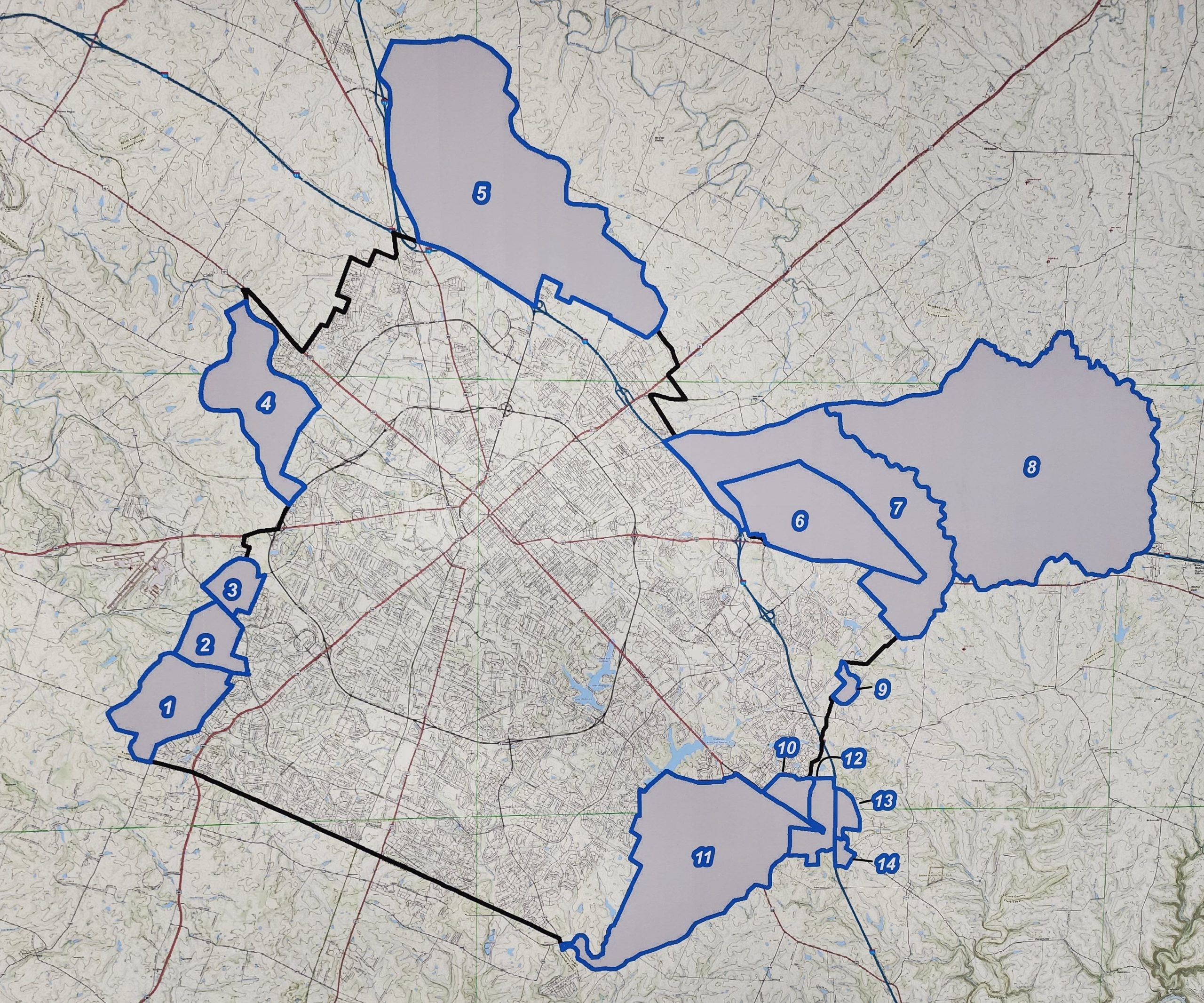
While areas 7,8, and 11 seem to have the most developable acreage, the lines on a map and the numbers alone don’t tell the whole story. Whether those acres are appropriate for development, the cost of building infrastructure, how much acreage is necessary to meet our future needs, and how to protect agricultural industries are all additional criteria to be considered.
Cost
The Growth Management Plan Advisory Committee has not yet been presented with the data on what it will cost to sewer each of the 14 study areas. That information is forthcoming and will be presented at next week’s meeting on Tues., Aug. 22 at 10 a.m.
During this time, the committee will be presented with a “Cost per Developable Acre” metric.
- Important: This metric serves as a basis of cost but is not an absolute.
- Also: This metric will not include other additional development fees such as design, property acquisition, legal, project management, inspection, and more — which can add significant costs that are currently unaccounted for.
Closing
While sewerability is a key piece of growth discussions, it is not the only information that should inform growth policy. Protecting prime farmland, the long-term cost to the community for new infrastructure, how much land is actually necessary to meet our growth needs, and more, are all pieces that must be further researched to inform decision-making about where growth might be appropriate in the Rural Service Area.
We will continue to keep you updated on the committee work, as well as on the work Fayette Alliance is doing to inform some of these questions, in the coming weeks.
8.22.23 — Urban Growth Management Locational Considerations
This week’s Urban Growth Management Advisory Committee meeting focused on beginning to examine priority areas on the map for future development.
- Important: Committee members were presented with considerations for identifying locations for expansion, which are outlined below, and then different areas were scored based upon those factors. The finalized report of the long-awaited Sewer Capability Study has been released – and the cost estimates to build sewer infrastructure outside the existing USB are key to this analysis – but were not touched on during the meeting.
- Also: Committee members were repeatedly told they could only focus on factors that Council outlined in the Goals & Objectives when they were choosing locations for expansion and the size of the expansion area. Other factors such as transportation networks, types of uses, and more are intended to be dealt with by a planning consultant when drafting the expansion area master plan, after areas are chosen for consideration.
In order to better understand the feasibility of developing outside the Urban Services Boundary, each of the 14 areas was given a score based on the following criteria:
- Total Developable Acreage
- Roadway Frontage
- Contiguous to the current Urban Services Area
- PDR Impact
- Specialized Areas
- LFUCG Participation (how much taxpayer funding would be required)
- Parcel Size
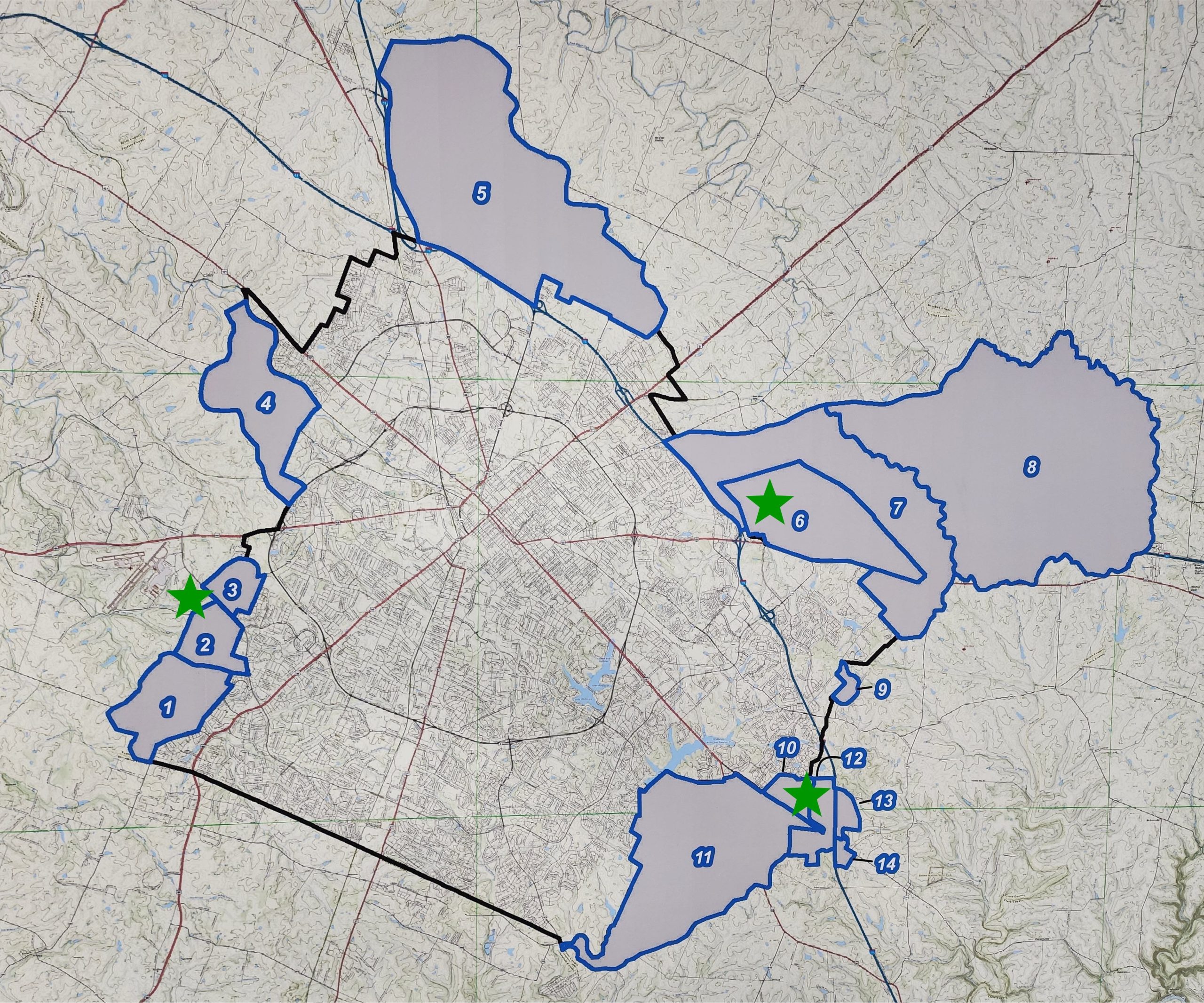
After ranking each of the 14 areas based on the above criteria, the committee agreed upon five areas that they believe could be incorporated into Lexington’s Urban Services Area.
- Top 5: Areas 2,3,6,10, and 12 are the portions that have been identified by the committee for potential future development, and each one will be examined more closely at next week’s meeting.
- Andi Johnson of Commerce Lexington requested that additional areas be examined, including Areas 13 and 14, despite their lower ranking.
- Todd Johnson of the Homebuilders Association requested that additional areas be examined, including Area 7, despite its lower ranking, much as a result of the high number of PDR-protected farmland in the area and smaller parcel size.
By the Numbers
Area 2, Mint Lane
- Total Developable Acres = 537
- Cost per Developable Acre = $36,413
- Opinion of Probable Construction Cost = $19,590,000
Area 3, Man O’ War
- Total Developable Acres = 336
- Cost per Developable Acre = $39,732
- Opinion of Probable Construction Cost = $13,350,000
Area 6, Royster Road
- Total Developable Acres = 1921
- Cost per Developable Acre = $154,477
- Opinion of Probable Construction Cost = $296,750,000
Area 10, Athens-Boonesboro
- Total Developable Acres = 273
- Cost per Developable Acre = $18,425
- Opinion of Probable Construction Cost = $5,030,000
Area 12, Boonesboro Manor
- Total Developable Acres = 428
- Cost per Developable Acre = $4,370,000
- Opinion of Probable Construction Cost = $10,210
Closing
With the top five areas selected, the committee is using that framework to understand where Lexington can grow and also has an approximation of what it will cost to provide sewer services in those areas.
- Thought: Throughout this expansion process, our leaders have focused on figuring out where Lexington can grow. However, very few posed the question of how much land is necessary to accommodate future growth, what our projected future growth actually is, and whether or not we should grow.