Details: New Expansion Area Map
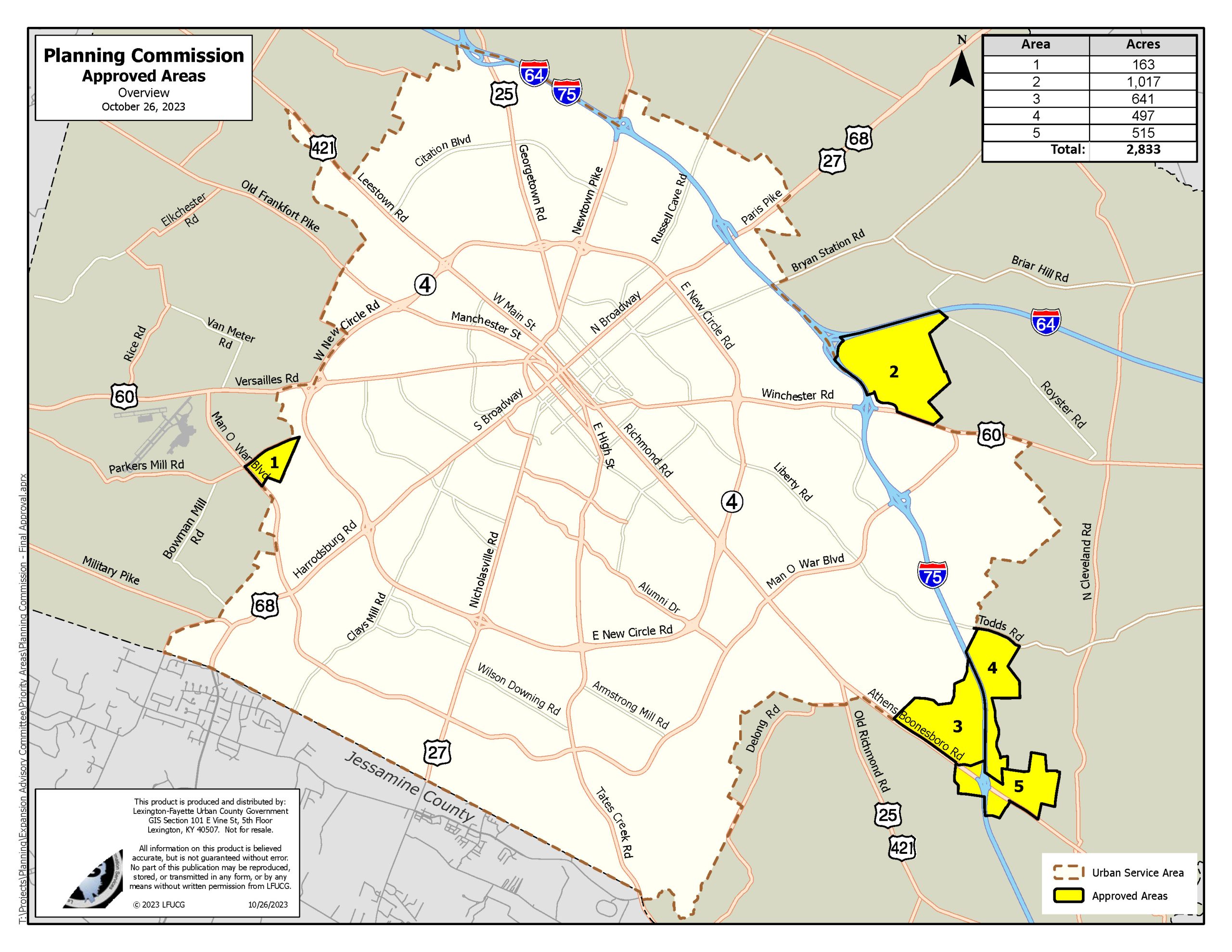
On Thurs., Oct. 26 2023, Lexington’s Planning Commission voted 6-4 to adopt a new expansion area map that will ultimately expand Lexington’s historic Urban Services Boundary by 2,833 gross acres.
- Next Steps: The newly adopted map will now move to the master planning phase with outside consultants.
Let’s be clear – this is a win for smart growth in Lexington-Fayette County during the ongoing and difficult conversation about a mandated expansion.
Increasing the USB by 2,833 acres is still significant, and not to be taken lightly – but ultimately, limiting the acreage selected to be as close to the minimum mandated as possible, in locations which have the least negative impact, is the most responsible choice.
- Important to remember: Data shows we already have 6,000+ acres of vacant land and an estimated 9,000+ acres of underutilized land within the existing USB. Developed efficiently, this land can accommodate our growth needs for decades to come – without even considering new areas for expansion.
- Moving forward: Limiting new expansion areas mandated by the Council, protecting prime farmland, and promoting redevelopment of underutilized areas will be key to responsible, sustainable future growth.
Here’s What We Like
The amount and location of the land chosen for expansion by the Planning Commission:
- Demonstrates an effort to protect prime farmland.
- Will minimize negative impacts on our agricultural areas.
- Promotes connectivity within expansion areas
- And encourages efficient use of existing underutilized land.
Thank you
Facing an unprecedented mandate from the Urban County Council, with limited data and a tight deadline, the Urban Growth Management Advisory Committee and the Planning Commission put their noses to the grindstone and worked to make the best decisions possible for Lexington-Fayette County under difficult circumstances. These recommendations can help move our city forward in a responsible, thoughtful way
- Thank you to the Urban Growth Management Advisory Committee and the Planning Commission for their work throughout this process.
- And, thank you to all the advocates who made their voices heard for smart growth during these discussions. Your voice made a difference.
Fayette Alliance will continue to fight for a data-driven process for future growth decisions in Lexington-Fayette County. This work is far from over, and we’ll continue to need your engagement as we forge ahead.
Land
The following changes were made from the Advisory Committee’s recommendations:
- Parkers Mill/Man O’ War: Only land located north of Man O’ War Boulevard and Parkers Mill Road was chosen for inclusion, excluding the opposite side of Parkers Mill Road closest to Versailles Road (previously shown as Area 1 on the September 19th maps).
- Winchester Road: The portion of land located south of Winchester Road, along N. Cleveland Rd. and Walnut Grove Lane, previously identified as Area 3 on the map from September 19, was removed from the expansion map, protecting hundreds of acres of active agricultural operations and prime farmland.
- Blue Sky: The Blue Sky Rural Activity Center and land along the east side of I-75 were both added (depicted below as Area 4 and 5) to promote connectivity and redevelopment of existing underutilized commercial land outside the current USB.
Next Steps
Now that the Planning Commission has approved the expansion map, a master plan for the newly incorporated land will be created to help guide development.
- Need to know: The creation of the master plan will involve public input throughout the process. We’ll keep you updated on upcoming public input opportunities.
- Adoption: The Planning Commission will vote to adopt the master plan as an amendment to the 2045 Comprehensive Plan in late 2024.