Urban Sprawl’s Effect on Farmland
Despite the economic, environmental, and cultural significance of our precious Fayette County farmland…we are losing it at an alarming rate.
In 2005 the Inner Bluegrass Region, including Fayette County, was placed on the World Monuments Fund’s list of one of the one hundred most endangered cultural landscapes in the world…because of our alarming loss of farmland to sprawl development. The Taj Mahal in India, and the Great Wall in China are also on this list. USA Today estimated that 137 acres a day of prime agricultural land in the Bluegrass is lost to urban sprawl.
In addition, Fayette County has lost over 19,000 agricultural acres since 1997.
As mentioned above, in 2010, statistics were released showing that America loses an acre of farmland every minute. The U.S. has lost more than 6 million acres of farmland since 1997—amounting to the size of Maryland.
These are shocking statistics.
Although farmland preservation and progressive planning efforts have helped curb this effect, 6 years later there is still much more to be done in Lexington-Fayette County.
In 2007, the US census showed that there are 810 farms in Fayette County accounting for 29,796 acres of harvested cropland.
While these numbers are higher than they were in 2002, they are still much lower than in 1997. It is important that we continue to build momentum in the efforts to protect our signature land—the anchor of our environment, economy, and culture.
Click Here to learn more about the LFUCG PDR Program. Click Here to learn more about Bluegrass Conservancy and their efforts to protect the Bluegrass.Urban Sprawl threatens Rural Settlements in Fayette County.
Historic rural settlements such Athens, Jimtown, Uttingertown, Mattoxtown, and Coletown are threatened by encroaching urban development.
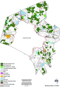
Many of these settlements are close to the current Urban Service Boundary, and if it is expanded, many will be in danger of encroachment and destruction.
With new development, many of these rural hamlets will experience an influx of traffic, noise, and commercial, industrial, and residential development—compromising their historic integrity and sense of place.
The 1996 Rural Land Management Plan recognized this potential problem, and expressly mandates their preservation. The plan states, “Historic rural settlements are an essential part of the rural character of Fayette County, and the rural land management plan requires the preservation and enhancement of these settlements.”
Currently, there are approximately 27,375 agricultural acres under conservation easement in Fayette County—preserving this farmland for agricultural uses forever.
However, farming and most forms of development cannot co-exist side by side, as the trespassing, noise, litter, and stormwater run-off caused by encroaching development makes it difficult for farms to operate in an economically feasible fashion.
Yet, Fayette County farmland is some of the most fertile in the world—ideal for agricultural production.
The topography of our soil consists of Maury Silt Loam soil associations. These associations are considered prime soils for row crops, equine and livestock production, and pasture land. They are located all over Fayette County from North to South and East to West:
Lower South Elkhorn: 774 acres consisting of prime agricultural or core equine agricultural land.
Man O’ War: 89% is core equine agricultural or prime agricultural land.
Old Frankfort Pike: 99% are core equine agricultural or prime agricultural land.
Ironworks Pike: 37% of land is core equine agricultural or prime agricultural land.
Avon/I-64: Over 70% is core equine agricultural or prime agricultural land.
Delong Road/Richmond Road: Over 82% is core equine agricultural or prime agricultural land.
Click Here to see a Fayette County soil map.
Click Here to see Fayette County soil descriptions.
Therefore, the expansion of our Urban Services Boundary into more farmland for development must be discouraged. We must focus our growth efforts inside our current city limits.
If done right, this approach will revitalize our urban areas—making Lexington a more attractive place to live—while also preserving our farmland, which is the factory floor of our significant $3 billion agricultural and agritourism industries.
Click Here to learn more about Lexington’s Urban Service Boundary.
For more information:
“Strategies for Developing Agricultural Opportunities in the Greater Lexington Area”, Dr. Timothy A Woods, U.K. Department of Agricultural Economics, 2005
LFUCG Purchase of Development Rights Program
Bluegrass Conservancy
2005 USDA Annual Report
“The Bluegrass battle: Horse farms vs. developers”, USA Today, November 2, 2005
“The Bluegrass Region: A Finite Resource”, UK Dept. of Landscape Architecture, 1999
USDA National Resources Inventory 2007
1996 Rural Land Management Plan


